

(NEW YORK) -- Tropical Storm Arthur has formed in the Gulf near the middle Texas coast, according to the National Weather Service (NWS). It is the first named storm of the Atlantic hurricane season.
Tropical storm warnings have been issued for upper Texas and Louisiana coastlines, meaning tropical storm conditions are expected in these areas in the next 12 to 24 hours. The NWS National Hurricane Center extended the warnings for more locations in Texas Wednesday afternoon as the storm strengthened.
Maximum sustained winds were near 45 mph around noon, according to the National Hurricane Center.
Arthur is expected to hug the coastline Wednesday and begin moving inland Wednesday night, weakening after it leaves the Gulf and moves inland over Louisiana.
The tropical threat is expected to produce rainfall totals of 5 to 10 inches, and some isolated totals up to 20 inches through early Friday from the Texas and Louisiana coasts into central Louisiana, parts of Mississippi, Alabama, Georgia and the Florida panhandle.
Life-threatening flash flooding is possible, according to the NWS. A flood watch is in effect from Houston to Atlanta.
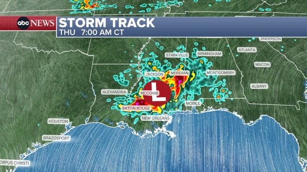
Over localized areas, storms may dump 2 to 4 inches of rain per hour. This could occur in areas including the region near Baton Rouge, Louisiana, and within the southern half of Mississippi, forecasts show.
The NWS Storm Prediction Center added a level 2 out of 5 "Slight Risk" for severe weather for parts of eastern Louisiana and southern Mississippi, including New Orleans, Baton Rouge, Gulfport and Hattiesburg.
Storm surge combined with the normal tide will cause normally dry areas near the coast to be flooded by rising waters moving inland from the shoreline. Between 2 to 4 feet of storm surge is possible from Port Bolivar, Texas, to Morgan City, Louisiana.
Isolated weak tornados are possible in southeast Texas, southern Louisiana and southern Mississippi Wednesday afternoon through night.
By 7 a.m. Thursday, the storm will bring heavy, potentially flooding rain to the Baton Rouge, Louisiana, area. The storm will have moved further east by 8 p.m. Thursday, bringing heavy rain from Atlanta to Montgomery to Mobile, Alabama.
On Friday morning, heavy rain will be possible in the Florida panhandle and parts of Carolinas by around 7 a.m.
Copyright © 2026, ABC Audio. All rights reserved.

.jpg)